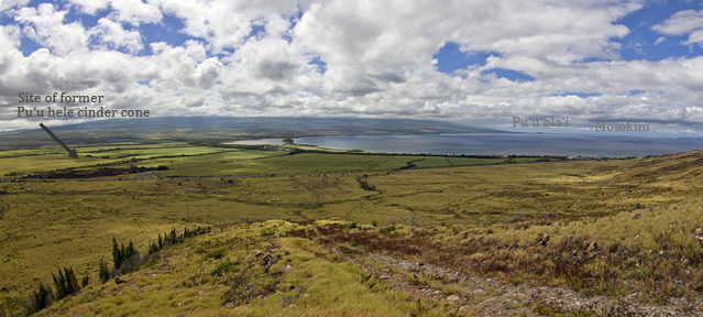
Central and South Maui showing site of former Pu‘u hele cinder cone with Pu‘u ola‘i and Molokini in the distance. Photo by P. Fiene.
Molokini Islet
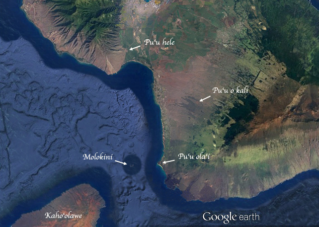
Molokini is a crescent-shaped islet a few miles off the southwest coast of Maui. Possibly the earliest written account of legends relating to the origin of Molokini Islet was by Jos. K. Kahele Jr. in the mid-1800s. It was later translated into English and published posthumously by A. Fornander in 1919. Kahele tells of a young lizard goddess named Pu‘u o inaina (Pu‘u o inaina means hill of wrath) – these demigod lizards could take the form of land features. She was the daughter of lizard gods who took the form of hills on Maui. Her mother was Pu‘u o kali in Kihei and her father was Pu‘u hele in Maalaea.
At some point her parents placed her on the island of Kaho‘olawe. Although she was married to two brothers, they were away much of the time, and eventually she took a new husband named Lohi‘au and forgot her own husbands. However, Lohi‘au was already married to the fire goddess Pele! When Pele heard of Pu‘u o inaina and Lohi‘au, she became angry. Pu‘u o inaina, getting wind of this, felt ashamed and retreated into the sea. Pele, on the way to see her husband, was blocked by Pu‘u o inaina’s father and so she had to wade through the sea. There she came upon Pu‘u o inaina stretched across the channel from Kaho‘olawe to Makena. In anger she cut her lizard rival in half – her head became Molokini and her body became Pu‘u ola‘i.
Molokini’s Mother
As we recounted in last month’s article, Molokini’s mother, Pu‘u o kali, is a cinder cone up on the hillside in Kihei. From that position she can see part of her lizard goddess daughter – she can see Molokini (the head) but she cannot see Pu‘u ola‘i (the tail).
Molokini’s Father
What about Molokini’s father, Pu‘u hele? He was a cinder cone in Maalaea and could see both parts of his daughter – both Molokini and Pu‘u ola‘i – from his location. But he no longer exists. How can that be? A cinder cone that does not exist anymore?!
When the cinder cone Pu‘u hele still existed, it was located at the junction of the Kihei and Wailuku Roads (now hwy 310 and hwy 30). It was a significant landmark because it was a little bit upslope and it stood 60 feet above the surrounding land. It could be seen from miles away.
Pu‘u hele during WWII
Then WWII came to Maui. Since cinder was an especially valuable material, the cinder cone Pu‘u hele was blasted and bulldozed and hauled away load by load. According to Inez Ashdown, a historian and story-teller of the time, the Navy, Seabees, Army and Marines all used the cinder to pave their service roads, to pave roads leading to Army and Marine camps, and in other locations as far away as Hana and Haleakala. After WWII a deep pit remained where Pu‘u hele had once stood. It was 120 feet deep – twice as deep as it had been tall.
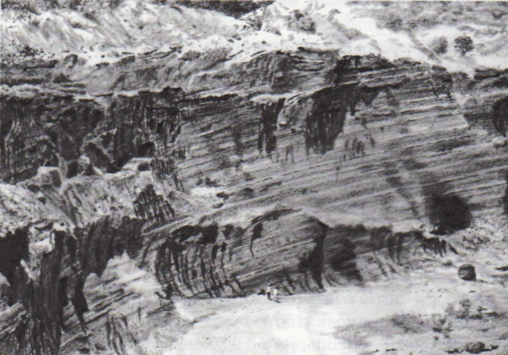
Pu‘u hele cinder pit, pre-1980. From “Maui How it Came to Be” by Will Kyselka and Ray Lanterman. Pit was 120 feet deep. Notice the curved vertical marks left by excavators.
Pu‘u hele cinder pit
During the years that it was a pit, it was interesting to visit. One could look into the pit and see back into time, roughly a quarter million years ago when Pu‘u hele was active. The layering of cinder varied depending on which particular explosive event deposited it and which way the wind was blowing at the time. One could also descend into the pit, and the size and depth made one feel small against the height of the sheer walls. Its depth inspired some Maui residents to go into it and shoot guns for recreation.
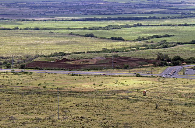
As of June 2017 work is in progress to cover and close the Pu‘u hele cinder pit construction dump. Photo by P. Fiene.
Pu‘u hele construction dump
It was still a pit when, in 1996, it became a construction dump. Over the next 20 years the pit was filled with construction and demolition debris, and a hill began to rise above ground level again. Its permitted height limit was 176 feet above sea level, which turns out to be 16-40 feet above the level of the sloping ground in that location. It approached that height in Sept. 2016 and was closed to further dumping. The remaining few feet are now being added in the form of soil and vegetation. When finished it will be about 20 feet lower than its original reported pre-mining height of 60 feet, and may give the appearance of the hill of old.
And now, here’s something to think about. The literal translation of Pu‘u hele is “traveling hill” [puu (hill) and hele (to go or move)]. Hawaiians may have given it this name because it was a landmark for anyone traveling in the area. But, as a result of WWII, it turned out that it fulfilled its literal translation, because load by load it literally traveled (was moved) to many places on Maui.
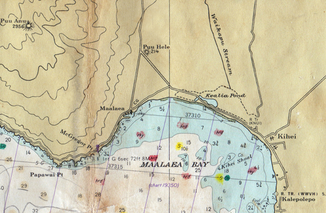
Old topographic map showing Pu‘u hele and its elevation of 214 feet above sea level. Map courtesy of Mike Severns.
Historic maps show Pu‘u hele as the 214-foot-elevation cinder cone it once was. If a newcomer sees Pu‘u hele on such a map, he will have no idea that the existing hill (when finished) is an imposter, the original hill having been moved all over the island, as its name foretold.
Written by Pauline Fiene. Photos as credited. Mahalo to Rob Nelson for hiking recon and endless discussion of Pu‘u hele and Pu‘u o kali 🙂
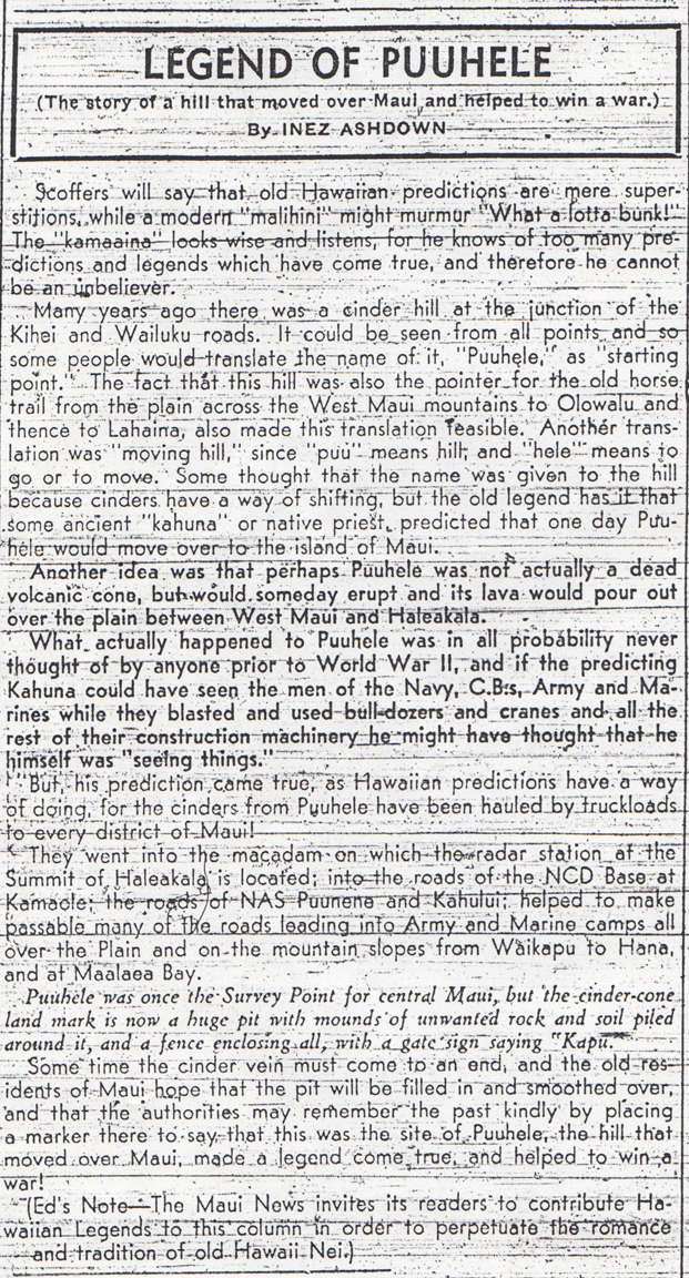
From the Maui News, Feb. 13, 1946, 8:3.
***********************
Ashdown, Inez. “Legend of Puuhele.” Maui News, Feb. 13, 1946, 8:3.
Kyselka, Will and R. Lanterman. Maui How it Came to Be. Honolulu: University of Hawai‘i Press. 1980.
Macdonald, G.A., and A. Abbott. Volcanoes in the Sea. Honolulu: University of Hawai‘i Press, 1970.
Pukui, Mary K., Samuel H. Elbert and E. T. Mookini. Place Names of Hawai‘i. Honolulu: University of Hawai‘i Press. 1974.
https://health.hawaii.gov/shwb/files/2015/09/Maalaea-Construction-and-Demolition-Landfill-Draft-Permit.pdf
http://www.mauinews.com/news/local-news/2016/01/planning-commission-grants-more-time-for-maalaea-landfill/

Comments 1
Fascinating. People see the land, sea, and air as static, and little could be farther from the truth. Thanks for enriching my grasp of “the rest of the story.”